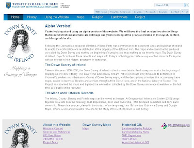
Trinity College Dublin has a great new website at http://phaedrus.cs.tcd.ie/petty/petty/index.php# (13 MAY 2013: see below for updated URL address). The project carries the Down Survey of Ireland, recorded by William Petty from 1656-58, the first detailed land survey of Ireland, and some gloriously beautiful Irish maps. Here's the blurb:
The Down Survey of Ireland
Taken in the years 1656-1658, the Down Survey of Ireland is the first ever detailed land survey and marks the beginning of mapping as we know it today. The survey was overseen by William Petty to measure every townland to be forfeited to Cromwell’s soldiers and adventurers. Copies of Down Survey maps, and the descriptions or terriers that accompany these maps, survive in dozens of libraries and archives throughout the British Isles, and in the National Library of France. This Project has scanned the maps and digitised the information collected by the Down Survey and made it available for the first time as a public online resource.
The Maps and Historical Records
The Ireland, County, Barony and Parish maps can be viewed as images. A Geographical Information System (GIS) brings together data sets from the following; 1641 Depositions, 1641 Land ownership, 1659 Townland population and 1670 Land ownership. These data sources, viewed in the context of contemporary, late 19th century Ordnance Survey and Google Maps, provide a new and invaluable resource for the study of this critical period in Irish history.
There's too much here to adequately describe - just go play with it, and have lots of FUN! :)
(With thanks to @findmypastie)
UPDATE 13 MAY 2013: The site's URL has now changed to http://downsurvey.tcd.ie/
Chris
My new book, Tracing Your Irish Family History on the Internet, is now available from Pen and Sword. For my other genealogy books, please visit http://britishgenes.blogspot.co.uk/p/my-books.html; whilst for my online Scottish based genealogy courses please visit the Pharos Teaching and Tutoring Ltd site.

No comments:
Post a Comment